All posts by Dan

Coastal forests catch fire

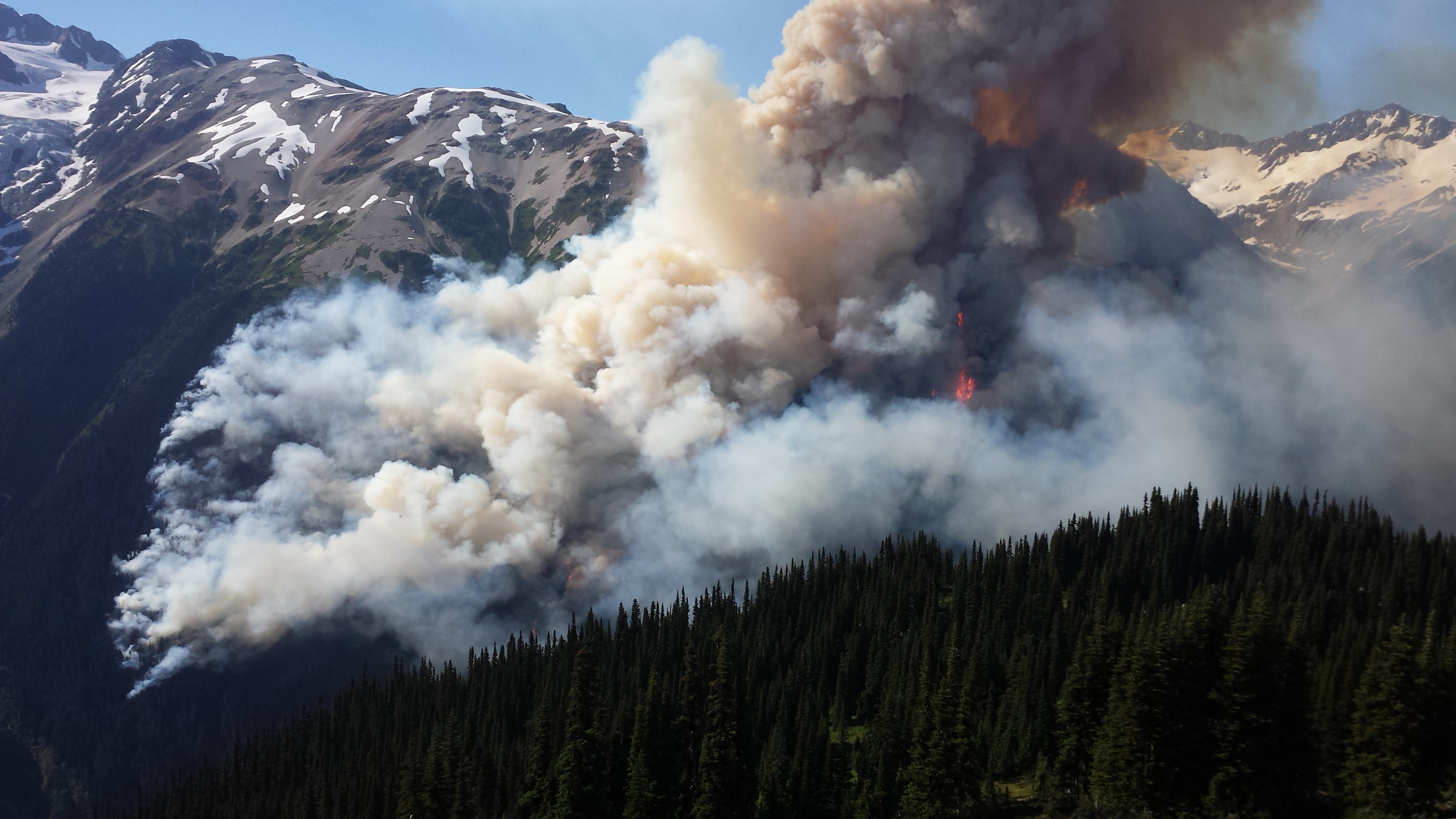
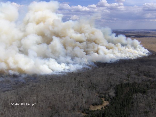
Fires are burning in coastal BC. This in itself is not a big deal, but the thick smoke in the air and local airtime devoted to the topic affirm its novelty. At least two fires in the (typically) wet Coastal Western Hemlock biogeoclimatic zone went from a few hundred hectares to several thousand in one afternoon and evening this past weekend; both fires were near the Whistler-Pemberton area, west and north of the Pemberton icecap glacier. Although the fires and their impact are not yet understood, the fire extents suggests that we may be experiencing a once-in-a century (or more) type of weather (and fire) event, the type of burning that defines a a 100 year (or 200, or 500 year) fire cycle. On the other hand, with our changing climate, this may become a more regular occurrence: our grand coastal temperate rainforests may now (or soon) be under the influence of something closer to a 50 year, or less, fire cycle.

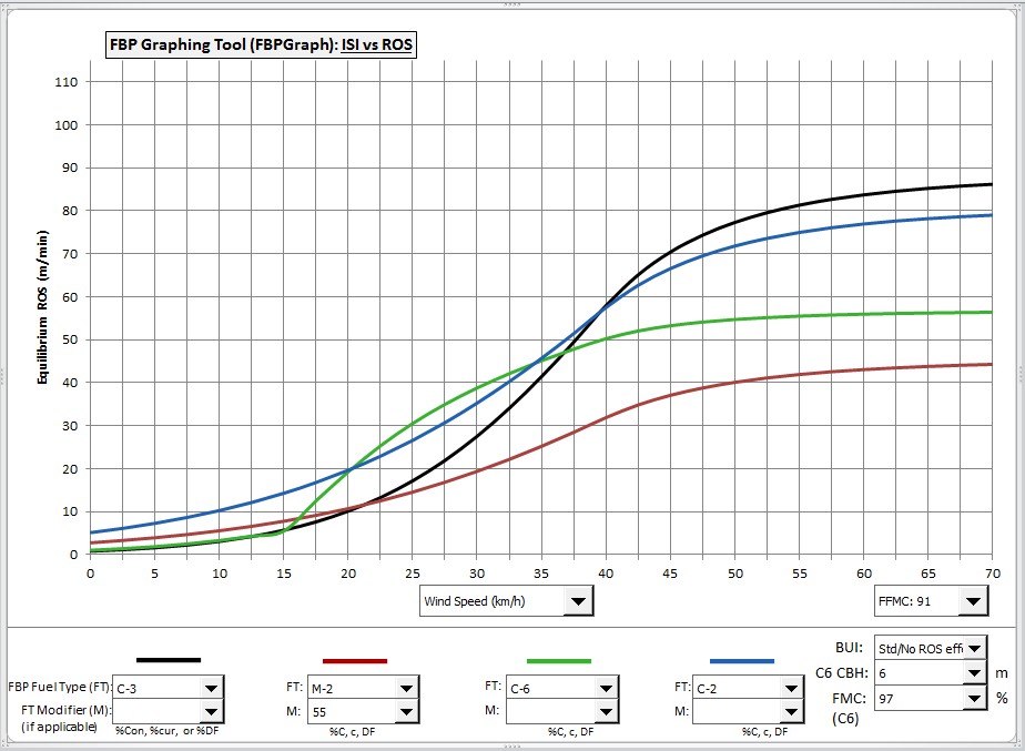
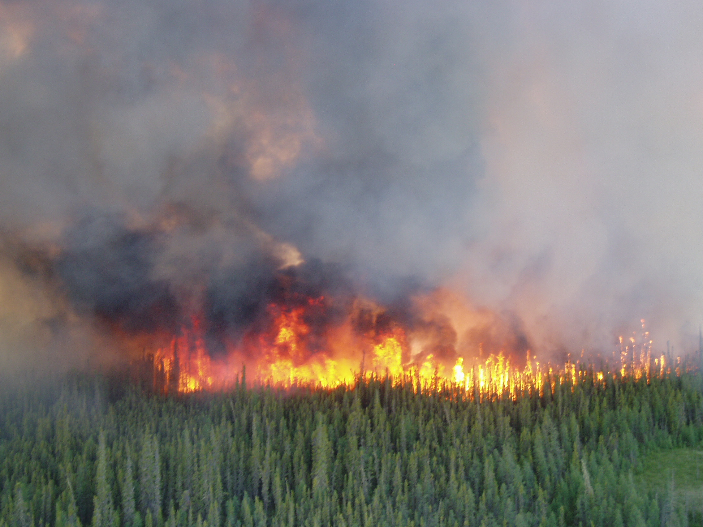
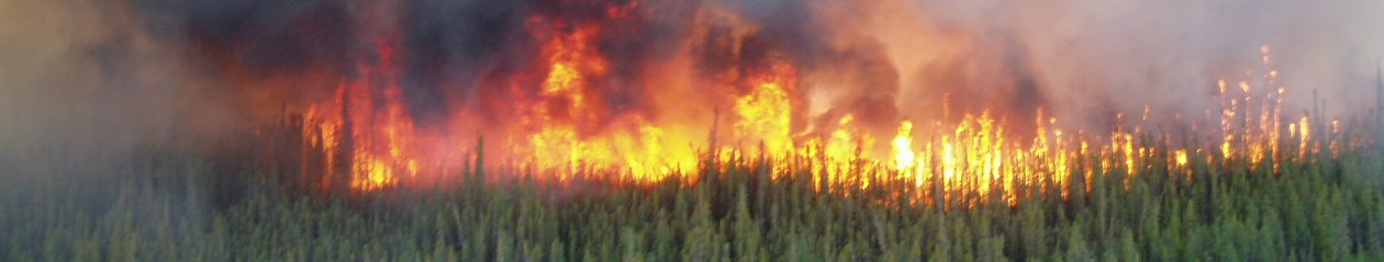
But I really wanted to write about fuel typing and fire behaviour. Fire behaviour modelers have struggled with what to do with west coast forests for years. They don’t burn easily, but when they do, it’s a big event. Mind you, it’s not the spread rate that is notable but rather the smoke emissions, and sometimes the fire intensity – there’s just a lot of biomass there, and when it dries out and burns, it’s a lot of combustion. When modeling fire behaviour in these stands, I tend to use the C-5 FBP fuel type model (developed in red and white pine stands in Ontario); although C-5 is kind of a weak-kneed fuel type (suggesting relatively slow-spreading, low intensity fires), the model nonetheless tends to overpredict fire behaviour in coastal forests most of the time. It’s just kind of hard to get fires going underneath the thick canopy that holds moisture so well. The fire behaviour of the past weekend hasn’t changed my mind on this – I think the C-5 rate of spread model may still be reasonable (or overpredict somewhat in most cases). Rather, the fuel consumption estimates from the model (and consequently fire intensity) may be underpredicted. Let’s call it a hunch. I wonder if I can get any data on this.

Boulder creek fire 2015_July2 growth

Tools for fire modeling: FBP Graph

Some time ago, Marty Alexander, Canadian fire behaviour guru emeritus, challenged me to put together a tool for comparing  the fuel types within the Canadian Fire Behaviour Prediction System (a sub-component of the Canadian Forest Fire Danger Rating System). I had already been interested in comparing the fuel types graphically to aid in fuel typing (deciding which FBP fuel types would best fit various patches of land based on characteristics such as tree species and density). This proved to be a very hand way to learn the details of the calculations within the FBP system.

The result is FBP Graph, an Excel graphing tool that compares spread rate and headfire intensity between up to 4 FBP fuel types simultaneously, with a fair amount of user control over the inputs and appearance. Although some day I may try to convert this to R or some more sophisticated platform, the Excel graphing format was handy for this purpose and should be familiar to most users.

The current version is 2.1, which allows for the x axis to be toggled between ISI (initial spread index) and wind speed, which is handy for forecasting the likely results of wind gusts and diurnal wind changes. Overall, I believe FBP Graph should be fairly self-explanatory to anyone with a good understanding of the FBP system (say, anyone who has been through the CIFFC Advanced Fire Behaviour course). Comments and suggestions are welcome.

Screen shots and download:

ScreenHunter_04 Dec. 17 11.23

FBPGraph_v2_1

Fire photos and videos

Who isn’t fascinated by wildland fire? I am privileged to be able to study such a cool phenomenon.

Here is a tasting of some great fire images from the great Canadian wild.

Just a random little fire, started by lightning somewhere in Wood Buffalo National Park (southern Northwest Territories), June 2006; landscape is typical of the boreal muskeg - poorly drained soil, lots of water, lots of organic material, small trees.
Just a random little fire, started by lightning somewhere in Wood Buffalo National Park (southern Northwest Territories), June 2006; landscape is typical of the boreal muskeg – poorly drained soil, lots of water, lots of organic material, small trees.
This is from a walk through a 2005 fire one year later - tens of thousands of jack pine seedlings per hectare, naturally regenerated following wildfire (pine cone is about 5-7 cm or 2-3 inches long).
This is from a walk through a 2005 fire one year later – tens of thousands of jack pine seedlings per hectare, naturally regenerated following wildfire (pine cone is about 5-7 cm or 2-3 inches long).


On the ecotone (ecosystem transition area) between the southern boreal plains and prairie grasslands of Saskatchewan; this is a 2009 prescribed burn in Prince Albert National Park designed to restore a grassland ecosystem. The fire is burning through a decadent stand of trembling aspen, burning as a relatively high intensity surface fire.


OLYMPUS DIGITAL CAMERA

This is a more typical fire photo for the boreal forest – high intensity active (continuous) crown fire burning through black and white spruce. This is probably the type of fire that created this stand in the first place. Wood Buffalo National Park, 2007.


Fire, carbon & climate interactions

This post relates the interactions between atmospheric energy and emissions and other effects of wildland fire. This is a topic that is very poorly-understood these days. I suspect that’s because it’s complicated, and policy-makers in particular do not respond well to a complicated decision-making environment.

The case for anthropogenic climate change in Canada remains very strong. I won’t debate this here. Sure, there’s some uncertainty over the degree of warming, the spatial and temporal scale of variability, and the various feedback mechanisms. But no one worth taking seriously is in doubt of the basic mechanisms; so far, the data is also supporting the model rather well. In any case, read the IPCC 4th Assessment Report (AR4), delve into the primary literature, do your due diligence on this.

The primary link of interest here is between carbon emissions from fossil fuels combustion and atmospheric energy. Fossil fuels burn, atmospheric energy is trapped in the lower atmosphere, temperature goes up. It’s not that simple, but it’s still relatively simple.There is no expectation that other landscape parameters would change as a result of the extraction and refinement of oil or its combustion to power passenger vehicles, for example.

When wildland fires burn, there are also carbon emissions released. But many other variables affecting atmospheric energy are also altered. These complicate the picture immensely.

The earth’s surfaces have a degree of reflectivity – the albedo – that indicates how much light of various wavelengths they absorb and how much they reflect back toward the atmosphere. Dark surfaces, such as asphalt, conifer forests, certain rocks, etc. absorb energy readily. They have low albedo. They heat up quickly in the sun (reradiating the energy as long-wave radiation). Other surfaces, such as snow, deciduous vegetation, light-coloured sand – these have high albedo and are much better reflectors of energy. They heat up less.

Putting it this way, it should not be surprising that when landscape characteristics change dramatically – such as what occurs following a wildland fire, logging operation, agricultural clearing, or subdivision construction – the albedo can change significantly. For example, Brian Amiro and colleagues found that both summertime and wintertime albedo varied along a successional gradient in boreal conifer stands in Canada, Alaska, and Russia: old conifer stands (> 100 years) had low albedo levels in both winter and summer, while younger stands (e.g. < 25 years) had much higher albedo, particularly in winter. This reflects partly the reflectivity of snow-covered relatively flat surfaces (young stands) as well as factors such as foliar moisture content and canopy height.

More to come…

Canadian Fire Management Links

Canadian fire management links – in Canada, most fire management responsibilities are carried out by provincial natural resource management agencies. The two main exceptions of note are Parks Canada and CIFFC.

British Columbia – Wildfire Management Branch (BC Ministry of Forests, Lands and Natural Resource Operations)

Yukon -Wildland Fire Management (YK Department of Community Services)

Alberta – Sustainable Resource Development/Preventing & Fighting Wildfire

Northwest Territories – Fire Management (NT Environment & Natural Resources)

Saskatchewan – SK Environment and Resource Management

Manitoba – MB Conservation Fire Program

Ontario – Aviation and Forest Fire Management (ON Ministry of Natural Resources)

Quebec – Societe de protection des forets contre le feu (SOPFEU)

Parks Canada Agency – PCA Fire Management Program

Canadian Interagency Forest Fire Centre – CIFFC

Getting started

Greetings! This is the personal fire ecology blog of Dan Perrakis, Ph.D. I am currently a fire researcher working for a provincial agency in western Canada (if I don’t actually mention my employer, hopefully I can avoid any conflicts at work related to content here!). I am interested in most topics related to wildland fire, including fire effects, fire behaviour, and fire management. I hope to ultimately have papers and discussions posted here as a resource for the fire ecology community.